Dr. Karol Carminatti Baumgärtner
Professor at the University Centre of the Educational Foundation of Brusque (UNIFEBE) Brazil, GCHU Global Visiting Research Associate
_________________________________________________________________________
In recent months, as a Visiting Researcher at the Global Centre on Healthcare and Urbanisation (GCHU) at the University of Oxford, I have been immersed in an environment that encourages a particular kind of thinking – one that crosses disciplinary boundaries and invites us to reconsider what we take for granted about cities.
Coming from southern Brazil, where my work focuses on small and medium-sized cities, this experience has been both intellectually enriching and, at times, provocative. It has reinforced a question that has guided much of my research in recent years: how can cities respond to the climate crisis when the tools available to understand urban reality are fragmented, inaccessible, or simply non-existent?
In many of the contexts in which I work, cities are challenged to deal with increasingly complex issues: rising temperatures, extreme climate events, socio-spatial inequalities, and public health vulnerabilities, often with limited institutional capacity, scarce data, and restricted financial resources. Yet planning processes frequently rely on indicator systems that are overly abstract or disconnected from the realities they seek to represent. It is precisely within this tension – between complexity and operational limitation – that my research in Oxford is situated.
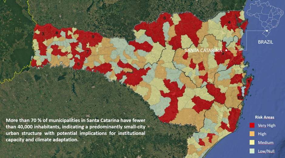
Fig 01: Map of the state of Santa Catarina showing areas at risk of flooding, drought, flash floods and other weather-related events. Source: Prepared by the author based on 2016 data from the Santa Catarina Civil Defence
At GCHU, discussions take place at the intersection of urban planning, environmental change, and social engagement. This interdisciplinary environment makes clear that cities cannot be understood through isolated variables. Urban form, environmental exposure, governance structures, and social dynamics are not separate layers; they are deeply interconnected components of a single system. However, much of contemporary urban analysis and practice still treats them as if they were independent.
This fragmentation is not merely a methodological issue; it has practical consequences. When urban methods and indicators fail to capture the relationships between these dimensions, they risk producing partial diagnoses, and consequently, incomplete or ineffective interventions. Reflecting on this during my time in Oxford led me to revisit the foundations of my own work.
It was through this process that I sought to address a question that has accompanied me throughout recent years of research. The development of FORMA (Framework for Operational Resilient and Multidimensional Assessment) was informed by the systematic review and synthesis of more than 400 urban indicators (TACAR, Ecological Urbanism, Biorubanism, Euro-URHIS, and others) and analytical frameworks developed globally. Conceived as an attempt to overcome these gaps, the framework is operationalised through a system of 116 Urban Habitability Indicators, structured across multiple dimensions and scales, designed to translate open data into actionable territorial intelligence. At its core, it seeks to assess what I have termed urban habitability, understood as the articulation between urban form, climatic conditions, and public health.
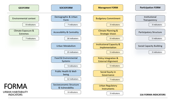
Fig 02: List of indicators used to structure the research. Source: compiled by the author.
The method operates across multiple scales – city, neighbourhood, street, and building – and is structured around four interconnected dimensions: Geoform, related to the natural attributes of the territory; Socioform, which addresses socially produced urban structures; Management Form, which considers the influence of public policies; and Participation Form, which recognises the community as a central element in the construction of the city.
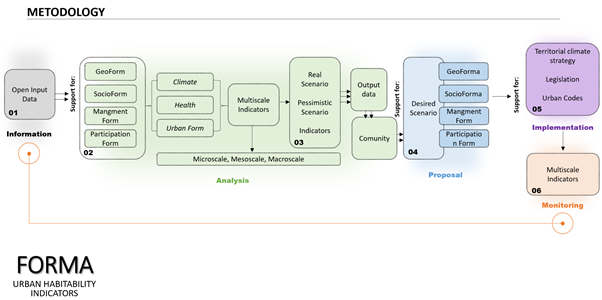
Fig. 03: Methodological procedures for applying FORMA. Source: Prepared by the author.
In many cities, particularly in the Global South, the challenge lies not only in the absence of tools capable of translating urban complexity, but also in the difficulty of transforming knowledge into action. In some cases, data exist, but remain fragmented, difficult to interpret, or disconnected from decision-making processes. As a result, planning tends to be reactive rather than strategic, and interventions often address symptoms rather than structural causes. The framework ultimately produces a composite index (ranging from 0 to 1), allowing cities to be classified according to their level of urban habitability.
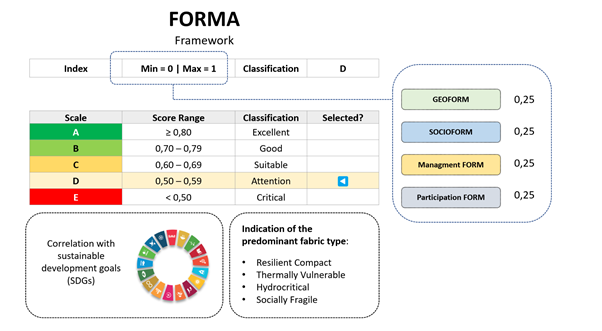
Fig. 04: Output from the Forma Framework, which produces a ‘Urban Liveability’ scale based on the indicators studied, correlating these with the SDGs and identifying the predominant types of urban fabric that are more or less resilient. Source: Prepared by the author.
FORMA was designed not for data-rich global capitals, but for cities operating under constraints, where clarity, usability, and adaptability are essential. By structuring complex data into multidimensional and interpretable indicators, it supports more informed and context-sensitive decision-making processes. Beyond diagnosis, it enables continuous monitoring, allowing cities to track change over time and adjust strategies accordingly.
During my time in Oxford, it became increasingly clear how this condition is not exclusive to a specific region. However, its consequences are significantly more pronounced in contexts where vulnerabilities are already high and institutional capacity is limited. Initial applications in southern Brazil suggest that urban vulnerability is often less a purely environmental condition than an institutional and participatory one.
Oxford, in this sense, offered a particularly conducive environment to reflect on these dynamics. The city functions as an ecosystem where urban form, institutional presence, and social interaction are deeply intertwined, creating conditions that actively support the production and exchange of knowledge. Importantly, the spatial configuration of Oxford itself plays a fundamental role in structuring everyday life, distributing opportunities for social appropriation across a finely grained and highly walkable urban fabric. Its urban atmosphere encourages movement, observation, and encounter, bringing together a remarkable diversity of places and people. This creates a continuous invitation to walk, explore, and engage with the city as a living laboratory.
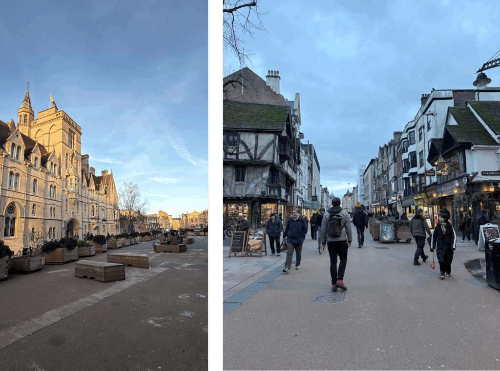
Fig. 05: Places to meet and interact in Oxford; Broad street (left) and Cornmarket street (right); Source: Author’s collection.
In this context, places such as the Bodleian Library, the Natural History Museum, and Tirah Memorial in Bonn Square became more than symbolic landmarks; they operated as strategic sites for studying and observing everyday urban life. Through these experiences, it became evident that knowledge is not confined to formal settings, but is constantly produced through the interaction between space, institutions, and social practices.
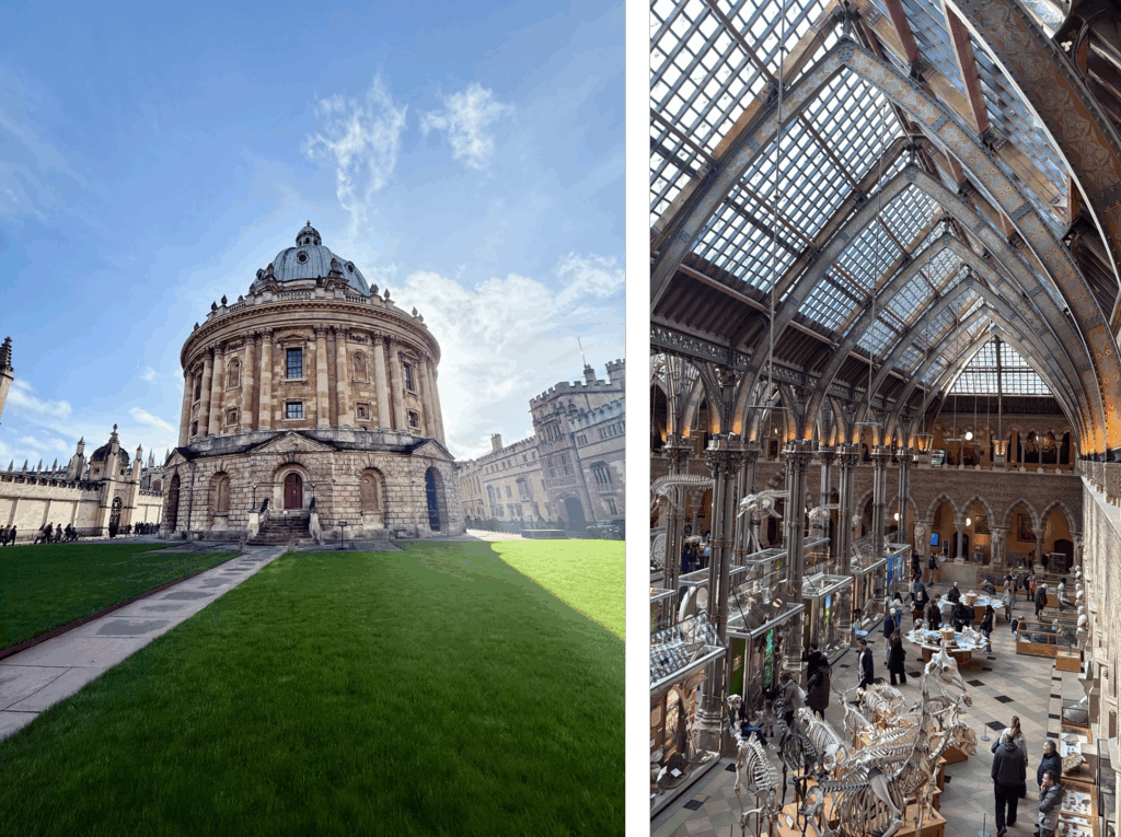
Fig. 06 The Radcliffe Camera which is part of the Bodleian Library (left) and the The Natural History Museum (right). Source: Author’s collection.
However, beyond its physical and institutional structure, Oxford revealed something even more fundamental: the role of human connections. Over the course of two months, numerous individuals contributed to this process, closely accompanying my development as a researcher. My colleagues at GCHU were a central source of support, facilitating collaborations with researchers from a wide range of institutions. Engagements with lecturers, researchers and professionals from Space Syntax, UCL and Oxford Brookes University expanded the analytical scope of the research, while experiences with The King’s Foundation and Oxford City Council introduced practical perspectives, adding rigour to the methodological approach I developed.
These experiences reinforce a central point: knowledge cannot remain confined to academia; it must circulate. It must be translated, adapted, and made accessible to cities, especially those operating under greater constraints. This has been one of the most important lessons from my time at the GCHU, and it directly informs how we understand and address urban vulnerability. I can cite, for example, the ENACT 15 mC project, which I had the opportunity to see up close, as it sparked an important debate on urban planning within the community.
Urban knowledge cannot be understood merely as an intellectual exercise. It is, fundamentally, a tool of care, a means of improving the conditions in which people live, move, and interact. When cities are unable to understand themselves, they become less capable of protecting their populations from environmental risks that directly impact public health. Conversely, when cities are able to read their own structures, to identify where vulnerabilities concentrate, where opportunities emerge, and how different systems interact, they become better equipped to act. As the impacts of climate change intensify, this capacity becomes increasingly critical.
The future of urban planning will depend not only on the production of new knowledge, but on our ability to make it operational, accessible, and meaningful across different contexts. This is particularly relevant for small and medium-sized cities, which often remain underrepresented in global debates despite housing a significant share of the world’s population.
My experience in Oxford has not provided definitive answers to these challenges. Rather, it has helped me sharpen the research questions that guide my work. Walking through the city, it became evident that urban form is not a neutral backdrop, but an active structure shaping how knowledge, interaction, and everyday life unfold. This has reinforced my conviction that the path forward lies not in simplification, but in integration, recognising cities as living, relational systems, where spatial configuration, institutional capacity, and social practices continuously interact. The challenge, then, is to translate this complexity into operational tools capable of supporting more responsive and inclusive forms of urban practice.
Hybrid seminar presented by Karol on 26th Feb 2026- “Urban Form, Nature and Health: Can We Measure Cities’ Habitability in a Climate Crisis?”.